Resources and Development – Class 10 Geography Notes, Concepts, and Map Work

- These concise and easy-to-understand revision notes are perfect for your exam prep.
- They cover all key topics such as types of resources, sustainable development, and resource conservation.
- You can also download the Class 10 Resources and Development notes in PDF format for printing and offline study.
|
Subject |
Social Science (Geography) |
|
Class |
10 |
|
Board |
CBSE and State Boards |
|
Chapter No. |
1 |
|
Chapter Name |
Resources and Development |
|
Type |
Notes |
|
Session |
2025-26 |
|
Weightage |
4 marks |
Table of Contents
- What
are Resources?
- Classification
of Resources
- Development
of Resources
- Resource
Planning
- Land
Resources
- Land
Utilization
- Land
Use Pattern in India
- Land
Degradation and Conservation Measures
- Soils
- Classification
of Soils
· Alluvial
Soils
· Black
Soil
· Red
and Yellow Soil
· Laterite
Soil
· Arid
Soils
· Forest
Soils
- Soil
Erosion and Soil Conservation

What are Resources?
Resources: Everything available in our environment which can be used to
satisfy our needs, provided, it is
- technologically accessible,
- economically feasible and
- culturally acceptable
can be termed as a ‘Resource’.
Interdependent relationship between nature, technology, and institutions:
- The process of transformation of things available in our environment involves an interactive relationship between nature, technology, and institutions.
- Human beings interact with nature through technology and create institutions to accelerate their economic development.
Classification of Resources

- On the basis of exhaustibility – renewable and non-renewable
- On the basis of ownership – individual, community, national, and
international
- On the basis of the status of development – potential, developed, stock, and reserves.
Classification of Resources
Development of Resources
The problems created as a result of indiscriminate utilization of
natural resources are:
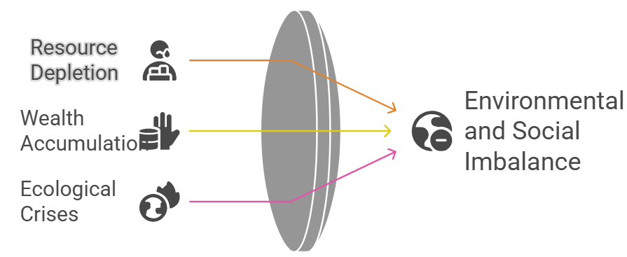
- Depletion of resources at a faster rate for satisfying the greed of
a few individuals.
- Accumulation of resources in few hands, as a result, dividing the
society into two segments i.e., haves and have-nots or rich and poor.
- Increase in global ecological crises such as global warming, ozone
layer depletion, environmental pollution, and land degradation.
Sustainable Development:
Sustainable economic development means ‘development should take
place without damaging the environment, and development in the present should
not compromise with the needs of the future generations.’
Rio de Janeiro Earth Summit, 1992:
Source: Google images

- The Summit was convened for addressing urgent problems of environmental protection and socio-economic development at the global level.
Agenda 21:
- Agenda 21 is the declaration signed by world leaders in 1992 at the United Nations Conference on Environment and Development (UNCED), which took place in Rio de Janeiro, Brazil.
- It aims at achieving global sustainable development.
The two principles are:

- To combat environmental damage, poverty, and disease through global
cooperation on common interests, mutual needs, and shared
responsibilities.
- Every local government should draw its own local Agenda 21.
Resource Planning
Need for resource planning

- Resource planning is a widely accepted strategy for the judicious
use of resources.
- Resources in India are not evenly distributed. Some parts of the
country are rich in one resource but deficient in other important
resources. For example – Rajasthan is rich in solar and wind energy but
lacks water resources. Jharkhand is rich in minerals and coal deposits but
lacks industrialization.
- Most of the resources present in our environment are limited.
Therefore, if these resources are not preserved or not used rationally we
will be in great trouble.
- To reduce regional disparity.
- To save for future generations and to avoid wastage or
overutilization of resources.
Three stages of resource planning
- Identification and inventory of resources across the regions of the
country. This involves surveying, mapping, and qualitative and
quantitative estimation and measurement of the resources.
- Evolving a planning structure endowed with appropriate technology,
skill, and institutional setup for implementing resource development
plans.
- Matching the resource development plans with overall national
development plans.
Land Resources
India has land under a variety of relief features, namely; mountains,
plateaus, plains, and islands.
- About 43% of the land area is plain, which
provides facilities for agriculture and industry.
- Mountains account for 30% of the total surface area of the country and
ensure the perennial flow of some rivers, providing facilities for tourism
and ecological aspects.
- About 27% of the area of the country is the plateau region. It possesses rich reserves of
minerals, fossil fuels, and forests.
Land Utilization
Land resources are used for the following purposes:
- Forests
- Land not available for cultivation
· Barren and wasteland
· Land put to non-agricultural uses, e.g. buildings, roads, factories,
etc.
- Other uncultivated lands (excluding fallow land)
· Permanent pastures and grazing land
· Land under miscellaneous tree crops groves (not included in the net sown
area)
· Culturable wasteland (left uncultivated for more than 5 agricultural
years)
- Fallow lands
· Current fallow (left without cultivation for one or less than one
agricultural year)
· Other than the current fallow (left uncultivated for the past 1 to 5
agricultural years)
- Net Sown Area
· the physical extent of land on which crops are sown harvested is known
as the net sown area.
- Gross cropped area
· Area sown more than once in an agricultural year plus the net sown area
is known as gross cropped area.
Land Use Pattern in India
Land use data is available only for 93% of the total geographical area
because
- the land use reporting for most of the northeast states except
Assam has not been done fully.
- Moreover, some areas of Jammu and Kashmir occupied by Pakistan and
China have also not been surveyed.
33% of the geographical area should be
under forest as mentioned in the National Forest Policy of 1952 because:
- it is essential for maintaining ecological balance.
- It provides a livelihood to millions of people who live on the
fringes of these forests and depend upon it.
Land Degradation and Conservation
Measures
- Mining: In states like Jharkhand, Chhattisgarh, Madhya Pradesh, and
Odisha deforestation due to mining has caused severe land degradation.
- Overgrazing: In states like Gujarat, Rajasthan, Madhya Pradesh, and
Maharashtra overgrazing is one of the main reasons for land degradation.
- Over-irrigation: In the states of Punjab, Haryana, and western Uttar Pradesh,
over-irrigation is responsible for land degradation due to water logging
leading to an increase in salinity and alkalinity in the soil.
Ways to Prevent Land Degradation:
- Afforestation and proper management of grazing.
- Planting of shelter belts of plants, control over grazing, and
stabilization of sand dunes by growing thorny bushes are some of the
methods to check land degradation in arid areas.
- Proper management of waste lands, control of mining activities, and
proper discharge and disposal of industrial effluents and wastes after
treatment can reduce land and water degradation in industrial and suburban
areas.
Soils
Factors on which soil formation depends:
- Relief, parent rock or bedrock, climate, vegetation, and other forms
of life and time are important factors in the formation of soil.
- Various forces of nature such as changes in temperature, actions of
running water, wind, and glaciers, activities of decomposers, etc.
contribute to the formation of soil.
- Chemical and organic changes which take place in the soil are
equally important.
Classification of Soils

Alluvial Soils
Alluvial soil is found in the entire northern plain. It is the most
widely spread soil in India.
The main features of alluvial soil are:
- It is formed by the sediments deposited by river water.
- It consists of various proportions of sand, silt, and clay.
- It is very fertile. It contains an adequate proportion of potash,
phosphoric acid, and lime.
- It is ideal for the growth of sugarcane, paddy, wheat, and other
cereals.
- Due to its high fertility, regions of alluvial soils are
intensively cultivated and densely populated.
On the basis of age, alluvial soils can be classified into: Khadar and
Bangar.
|
Khadar |
Bangar |
|
It is a new alluvial soil. |
It is an old alluvial soil. |
|
Lower concentration of kankar nodules. |
Higher concentration of kankar nodules. |
|
It has more fine particles. |
It has less fine particles. |
|
It is more fertile. |
It is less fertile. |
Black Soil
The following are the characteristics of regur soil (also known as black
soil):
- It is made up of extremely fine clayey material. They are
well-known for their capacity to hold moisture.
- It is rich in soil nutrients such as calcium carbonate, magnesium,
potash, and lime.
- These soils are generally poor in phosphoric contents.
- They develop deep cracks during hot weather, which helps in the
proper aeration of the soil.
- It is ideal for growing cotton, so it is also known as ‘black
cotton soil’.
Red and Yellow Soil
- Red soil develops on crystalline igneous rocks in areas of low
rainfall in the eastern and southern parts of the Deccan plateau.
- Yellow and red soils are also found in parts of Odisha,
Chhattisgarh, southern parts of the middle Ganga plain, and along the
piedmont zone of the Western Ghats.
- These soils develop a reddish color due to the diffusion of iron in
crystalline and metamorphic rocks.
- It looks yellow when it occurs in a hydrated form.
Laterite Soil
- The laterite soil develops under tropical and subtropical climates
with alternate wet and dry seasons.
- This soil is the result of intense leaching due to heavy rain.
- Lateritic soils are mostly deep to very deep, acidic (pH<6.0),
and generally deficient in plant nutrients
- Occurs mostly in southern states, the Western Ghats region of
Maharashtra, Odisha, some parts of West Bengal, and the North-east
regions.
Arid Soils
- Arid soils range from red to brown in color.
- They are generally sandy in texture and saline in nature.
- In some areas, the salt content is very high, and common salt is
obtained by evaporating the water.
- Due to the dry climate, and high temperature, evaporation is faster
and the soil lacks humus and moisture.
Forest Soils
- They are loamy and silty on valley sides and coarse-grained on the
upper slopes.
- In the snow-covered areas of the Himalayas, these soils experience
denudation and are acidic with low humus content.
- The soils found in the lower parts of the valleys, particularly on
the river terraces and alluvial fans are fertile.
Soil Erosion and Soil Conservation
Soil erosion is the displacement of the upper layer of soil, caused by
various agents such as water, wind, and human activities. This can lead to loss
of fertile land, reduced crop yields, and increased risk of landslides and
flooding.
Types of soil erosion:
- Gullies: The running water cuts through the clayey soil and makes
deep channels/gullies. The unfit land caused by gullies is called bad land
or ravines (bad land called ravine in the Chambal basin).
- Sheet erosion: Water flows as a sheet over large areas down a
slope. The topsoil is washed away. This process is known as sheet erosion.
Causes of soil erosion:
- Human activities like deforestation, over-grazing, construction,
mining, etc. are responsible for soil erosion.
- Natural forces like wind, glaciers, and water also lead to soil
erosion. Running water cuts through the clayey soil and makes deep
channels known as gullies, which makes the land unfit for cultivation. The
wind blows loose soil off flat or sloping land known as wind erosion.
- Soil erosion is also caused due to defective methods of farming.
Ploughing in the wrong way i.e., up and down the slope forms channels for
the quick flow of water leading to soil erosion.
Measures to prevent soil erosion:
- Contour ploughing: Ploughing along the contour lines can decrease
the speed of water flow down the slopes and soil erosion can be prevented.
- Terrace cultivation: Step or terrace cultivation on slopes
restricts erosion. Western and Central Himalayas have well-developed
terrace farming.
- Strip cropping: Large fields can be divided into strips and strips
of grass are left to grow between the crops. This breaks up the force of
the wind and prevents soil erosion.
- Shelter belts: Rows of trees called shelter belts have led to the
stabilization of sand dunes in the desert in western India.
CBSE BOARD EXAM PREVIOUS YEAR QUESTIONS
1 Mark Questions
-
Who designed the Swaraj Flag?
→ Mahatma Gandhi. -
What is the significance of the year 1930 in Indian nationalism?
→ Civil Disobedience Movement was launched with the Salt March. -
Who were the leaders of the Khilafat Movement?
→ Muhammad Ali and Shaukat Ali. -
What is the meaning of ‘Satyagraha’?
→ Non-violent insistence on truth and justice. -
When was the Rowlatt Act passed?
→ 1919. -
What happened on 13 April 1919?
→ Jallianwala Bagh massacre took place in Amritsar.
✅ 2 Marks Questions
-
Mention two effects of the First World War on India.
→ Price rise and forced recruitment of soldiers. -
State any two features of the Rowlatt Act.
→ No trial for political prisoners; detention without cause. -
Why did Gandhiji withdraw the Non-Cooperation Movement?
→ Due to the violent incident at Chauri Chaura in 1922. -
Name any two social groups who participated in the Civil Disobedience Movement. Why?
→ Rich peasants (wanted revenue reduction), women (symbolic nationalism). -
Why did the Khilafat Movement gain support in India?
→ Muslims wanted to protest against British insults to Caliphate; Hindus joined for unity.
✅ 3 Marks Questions
-
How did the Salt March become an effective symbol of resistance against colonialism?
→ Mass participation, broke unjust salt law, inspired nationwide civil disobedience. -
Why did the Non-Cooperation Movement slow down in cities?
→ Lack of alternative institutions, expensive khadi, and boycotts lost momentum. -
What was the significance of the Lahore Congress of 1929?
→ Resolution of ‘Purna Swaraj’ passed; 26 January declared Independence Day. -
Why did rich peasants and business classes support the Civil Disobedience Movement?
→ Wanted to reduce taxes and protect indigenous industries from British control. -
What were the effects of the Jallianwala Bagh incident on Indians?
→ Shock, anger, and strengthened anti-British feelings across the nation.
✅ 5 Marks Questions
-
Explain the economic, political, and social impact of the First World War on India.
→ Heavy war expenditure, taxes and prices rose, forced recruitment, crop failures, and influenza epidemic created national discontent. -
Describe the main features of the Civil Disobedience Movement.
→ Launch with Salt March, breaking of salt law, boycotts, refusal to pay taxes, foreign cloth picketing, mass involvement. -
How did different social groups participate in the Civil Disobedience Movement?
→-
Rich peasants: protested against high revenue.
-
Poor peasants: wanted rent relief.
-
Businessmen: opposed colonial restrictions.
-
Women: participated in picketing and marches.
-
-
How did cultural processes help in creating a sense of collective belonging in India?
→-
Symbols like Bharat Mata.
-
National songs like Vande Mataram.
-
Reinterpretation of Indian history.
-
Promotion of folklore, festivals, and common heritage.
-
-
Why did Gandhiji launch the Salt March? How did it become a mass movement?
→-
To protest British monopoly on salt.
-
Thousands joined, broke salt laws, picketed shops, showed united defiance across regions and classes.
-
NCERT QUESTIONS ANSWERS:
Q1. What do you mean by ‘Satyagraha’?
Ans:
Satyagraha is a non-violent method of protest introduced by Mahatma Gandhi. It means the "insistence on truth." It aims to bring change through moral force rather than physical force.
🔸 Page 34
Q2. Why did Gandhiji decide to launch a nationwide Satyagraha against the Rowlatt Act (1919)?
Ans:
The Rowlatt Act allowed the British to arrest Indians without trial. Gandhiji saw it as unjust and a denial of civil rights. He called for a peaceful protest against it through Satyagraha.
🔸 Page 36
Q3. Why did the Non-Cooperation Movement gradually slow down in the cities?
Ans:
-
Khadi was expensive.
-
Alternative Indian institutions were limited.
-
Students and teachers returned to government schools.
-
Lawyers resumed practice in British courts.
🔸 Page 40
Q4. How did different social groups participate in the Civil Disobedience Movement?
Ans:
-
Rich peasants: protested against high land revenue.
-
Poor peasants: wanted reduction of rent and unpaid debts.
-
Industrialists: supported to reduce colonial trade barriers.
-
Workers: were inspired but not fully involved.
-
Women: participated in marches and picketing.
🔸 Page 41
Q5. Why did Gandhiji relaunch the Civil Disobedience Movement in 1932?
Ans:
-
The Gandhi-Irwin Pact failed.
-
British continued repression.
-
Gandhiji resumed the movement to continue the struggle for freedom.
🔸 Page 43
Q6. What do you understand by the term ‘sense of collective belonging’?
Ans:
It refers to the feeling of being part of one nation. It was created through common symbols (flag, songs), history, folklore, and cultural identity.
🟢 NCERT Exercise Questions & Solutions
🔸 1. Explain:
(a) Why growth of nationalism in the colonies is linked to an anti-colonial movement.
Ans:
Colonial rule exploited native people economically and politically. Shared experiences of oppression led to unity and the birth of nationalist movements aimed at independence.
(b) How the First World War helped in the growth of the National Movement in India.
Ans:
-
Economic hardship due to war loans.
-
Forced recruitment and price rise.
-
Led to political awareness and unity.
-
Prepared ground for mass movements.
(c) Why Indians were outraged by the Rowlatt Act.
Ans:
-
No trial for arrested people.
-
Restricted civil rights.
-
Seen as unjust and repressive.
(d) Why Gandhiji decided to withdraw the Non-Cooperation Movement.
Ans:
After the Chauri Chaura incident (1922) where police were killed in violence, Gandhi felt the movement was turning violent and withdrew it.
🔸 2. What is meant by the idea of satyagraha?
Ans:
Satyagraha is a non-violent resistance based on truth and justice. It was used by Gandhiji to oppose unjust laws and policies of the British.
🔸 3. Write a newspaper report on:
(a) Jallianwala Bagh massacre
Model Answer:
On 13 April 1919, General Dyer ordered open fire on a peaceful gathering in Amritsar’s Jallianwala Bagh. Over 1000 people were killed. It led to nationwide outrage and increased support for the national movement.
(b) Simon Commission
Model Answer:
In 1928, the British government sent the Simon Commission to India without any Indian members. It was boycotted across India with slogans of “Simon Go Back.” Lala Lajpat Rai was injured in a protest and later died.
🔸 4. Compare Non-Cooperation and Civil Disobedience Movements.
| Feature | Non-Cooperation Movement (1920) | Civil Disobedience Movement (1930) |
|---|---|---|
| Objective | Swaraj through non-cooperation | Complete independence via defiance |
| Methods | Boycotts of institutions and goods | Breaking laws (e.g., Salt Law) |
| Participation | Urban middle class, peasants | Peasants, women, industrialists |
| Outcome | Withdrawn after Chauri Chaura | Repressed, later revived by Gandhi |
🔸 5. Why were different social groups attracted to the Civil Disobedience Movement?
Ans:
-
Peasants wanted tax reduction.
-
Businessmen sought protection from British economic policies.
-
Women saw it as a national duty.
-
All were united in desire for freedom.
🔸 6. Why did the Muslim political organizations not fully participate in the Civil Disobedience Movement?
Ans:
-
Growing communal divide post-1920s.
-
Failure of Khilafat Movement.
-
Disagreements over political representation.
-
Feeling of underrepresentation in Congress.
🔸 7. Describe the role of folklore, songs, symbols in shaping nationalism.
Ans:
-
Folklore revived Indian heritage.
-
Songs like “Vande Mataram” created unity.
-
Symbols like Bharat Mata and the tricolor flag united people across regions.
🔸 8. List all the features of the Salt March.
Ans:
-
Started on 12 March 1930 from Sabarmati to Dandi.
-
240-mile journey by Gandhi and followers.
-
Protested British monopoly on salt.
-
Inspired nationwide Civil Disobedience.
#Class10Geography, #ResourcesAndDevelopment, #CBSE2025, #GeographyNotes, #SSTClass10, #NCERTGeography, #SoilTypesIndia, #SustainableDevelopment, #SoilConservation, #MapWorkClass10

Comments
Post a Comment